6/30/2009

Severe Weather Outlook Verification for June 30, 2009

Verification process complete and all severe weather reports are accounted for. A Slight Risk was indeed warranted as the amount and congestion of reports are more than ample enough to verify such a risk. As far as the models go, the NAM/RUC handily outperformed the GFS with this event, especially in terms of CAPE values as to what was actually realized. Here is the breakdown....

Total reports came to 45, of which, 25 Severe Wind Gusts/Wind Damage Reports, 20 Severe Hail Reports, and 0 Tornado reports/confirmations as of yet.

Of 45 total reports...

Slight Risk zone captured 42/45 severe weather reports.
15% Wind zone: captured 23/25 severe wind/damage reports.
15% Hail zone: captured 19/20 severe hail reports.
2% Tornado zone: captured 0/0 tornado reports/confirmations thus far. 1 Tornado warned cell in Sullivan/Delaware Counties NY did produce a Funnel Cloud and wind damage, although no confirmed/reported tornadoes. This could be subject to change.

Isolated Severe zone captured 2/45 severe weather reports.
5% Wind: 2/25 severe wind/damage reports.
5% Hail: 0/20 severe hail reports.

..EGAN..


Afternoon Day 1 Severe Weather Outlook for June 30, 2009

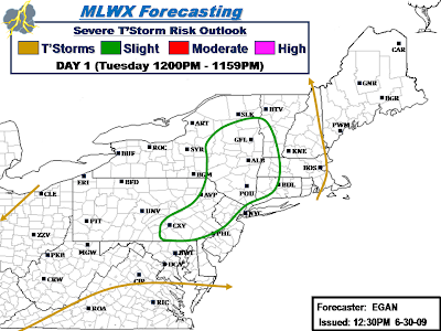
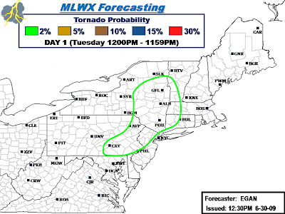
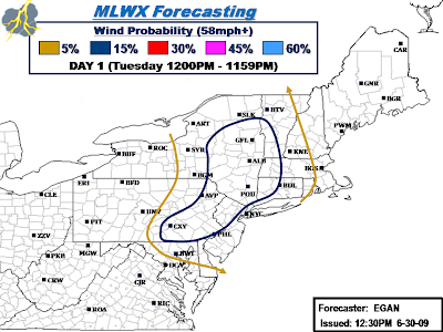
Midday D1 update complete. Overall, not much change to previous Overnight D1 Outlook(s), see Post #73. Based on latest RUC guidance, locally expanded Slight Risk northward to include a few more counties in VT/NY as moderate instability is forecasted to reach into this region. Based on latest convective trends, also locally extended risk to include a few more counties in Eastern PA. Last tweak was to bump up Damaging Wind probability to 15% and also include a low 2% Tornado Probability.

Tornado threat is still very low, but given some decent helicity being indicated by the latest RUC guidance (highest in the north), tornado threat is non-zero. Best chance for a brief isolated tornado will be with any discrete low-topped supercells that manage to develop this afternoon.

Newly updated Slight Risk includes the following counties...

New York: Albany, Chenango, Columbia, Delaware, Dutchess, Essex, Fulton, Greene, Hamilton, Herkimer, Madison, Montgomery, Oneida, Orange, Otsego, Putnam, Rensselaer, Rockland, Saratoga, Schenectady, Schoharie, Sullivan, Ulster, Warren, Washington, West Chester

Pennsylvania: Adams, Berks, Bucks, Carbon, Chester, Columbia, Cumberland, Dauphin, Delaware, Juniata, Lackawanna, Lancaster, Lebanon, Lehigh, Luzerne, Monroe, Montgomery, Northampton, Northumberland, Perry, Philadelphia, Pike, Schuykill, Snyder, Susquehanna, Wayne, York.

New Jersey: Bergen, Essex, Hudson, Hunterdon, Mercer, Middlesex, Morris, Passaic, Somerset, Sussex, Union, Warren.

Connecticut: Fairfield, Hartford, Litchfield, New Haven.

Massachusetts: Berkshire, Franklin, Hampden, Hampshire.

Vermont: Addison, Bennington, Rutland, Windham.


Day 1 Overnight Severe Weather Outlook for June 30, 2009

Overnight D1 Outlook is complete. A Slight Risk includes parts of Eastern PA/Northern NJ/Eastern NY/Western CT/Western MA/Extreme Southern VT.

Slight Risk includes the following counties:

New York: Albany, Chenango, Columbia, Delaware, Dutchess, Fulton, Greene, Hamilton, Herkimer, Madison, Montgomery, Oneida, Orange, Otsego, Putnam, Rensselaer, Rockland, Saratoga, Schenectady, Schoharie, Sullivan, Ulster, Warren, Washington, West Chester.

Pennsylvania: Berks, Bucks, Carbon, Lackawanna, Lehigh, Luzerne, Monroe, Montgomery, Northampton, Pike, Schuykill, Wayne.

New Jersey: Bergen, Essex, Hudson, Hunterdon, Mercer, Middlesex, Morris, Passaic, Somerset, Sussex, Union, Warren.

Connecticut: Fairfield, Hartford, Litchfield, New Haven.

Massachusetts: Berkshire, Franklin, Hampden, Hampshire.

Vermont: Bennington.

Discussion...

Overall consesus is that there will be a corridor of moderate MLCAPE on the order of 1350-2000 J/KG that develops this Afternoon/Evening over parts of the area. In conjuction, corresponding moderate negative LI's of -3 to -6 and Low Level Bulk Shear of 25-40kts (highest in the Southern portion of Risk) will be in place over this region thruout the Afternoon and into the Evening. This should allow for fairly widespread convection to fire this Afternoon, some of which will likely become severe.

Given lack of strong low level shear, storm organization will likely be fairly loose and feature Multi-Cell clusters/Pulse storms. Given the rather low freezing level in the mid-layers, expect hail to be the primary severe threat versus damaging winds. Have played this potential up in the Outlook probabilities. That said, isolated damaging wind gusts may still accompany the strongest cells.

Final Day 1 Outlook to be completed by midday, which may or maynot feature any changes to current Outlook.

..EGAN..


6/29/2009

Day 2 Severe Weather Outlook for June 30, 2009

Based on 0z/12z runs, think there is now enough of a threat to introduce a Slight Risk over a portion of the area. Slight Risk covers parts of Eastern NY/Western New England and includes areas such as Poughkeepsie NY-Albany NY-Glens Falls NY-Rutland VT-Keene NH-Hartford CT.

While no 1 severe weather perameter appears overly favorable for severe convection, all or most perameters are present and appear to be atleast modest in strength. Sufficient low level shear on the order of 30-40kts. coupled with modest lift of -3 to -6 and SBCAPE of 1500-2000 j/kg will be present over Eastern NY and adjacent Western New England during the Afternoon/Early Evening hours on Tuesday. Overall storm mode will likely feature muti-cellular clusters/line segments capable of large hail and isolated damaging winds. However, there is fairly good amount of low level Helicity forecasted which suggests the potential for a few low-topped rotating supercells to develop and further enhance associated hail threat.

..EGAN..


6/25/2009

Day 2 Severe Weather Outlook (Friday 6/26/09)

Slight Risk runs south/east of line extending from roughly Roanoke VA-Culpeper VA-Washington D.C.-Baltimore MD-Poughkeepsie NY-Keene NH.

Cold front will continue to work eastward across the interior Northeast overnight Thursday into Friday Morning. Both NAM/GFS advertise moderate to locally strong destabilization taking place out ahead of the front along the I-95 corridor by early afternoon. Moderate Negative Lift Indices will be co-located in this axis of destabilization which should support gradual increase in thunderstorms by early afternoon. Despite low level shear being somewhat weak, potential will be in place for strong to severe storms, especially along/east much of the I-95 corridor.

..EGAN..


Day 1 Severe Weather Outlook (Thursday 6/25/09)...

D1 Outlook is now on the street. Most noticeable difference in latest model runs is to pull back on the timing with the frontal passage. This will keep the best forcing back thru interior PA/NY thru the afternoon into the Evening hours as front approaches from Southern Canada. It is here where Slight Risk was most justifiable at the present time. Slight Risk will run north/west of a line from roughly Morgantown-State College-Binghamton-Burlington. Pending on how things look heading into Thursday Afternoon, further adjustments may be needed with Midday update.

While MLCAPE and negative lifted indices will be favorable for thunderstorm development during the Afternoon and Evening hours across interior parts of NY/PA, weak low level vertical shear and wind flow will prohibit much in the way of organized and widespread convection. However, given the amount of cold air aloft, cells that do manage to develop will need to be watched for associated hail threat. This event could be very reminiscent to recent June 15th event.

Given this setup, expect most of the convection that does manage to develop to be of the Pulse-type variety, with large hail, damaging wind, and heavy rainfall to be the primary threats. With weak helicity in the lower levels, tornado threat appears rather low at the present time.

..EGAN..