7/31/2009

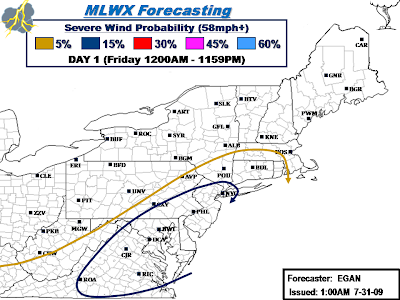
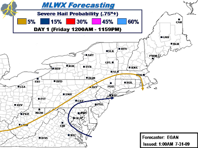
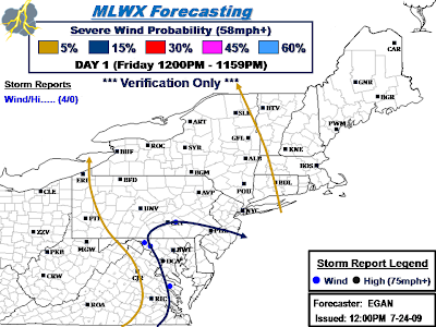
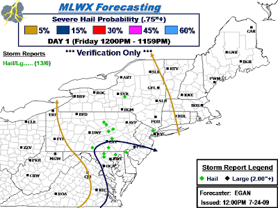
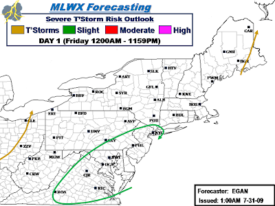
Severe Weather Outlook for Friday, July 31, 2009...

Discussion... as of 1AM 07/31/2009
Not much change from previous thinking. In the grand scheme of things, damaging straight-line winds will be the most widespread form of severe weather. However, where destabilization is maximized, potential for rotating supercells exists given the amount of right-turning in the 0-3km layer. Given the amount of helicity, and taking Wednesday's event with a grain of salt, hard to believe a few tornadoes won't occur by the end of the day. This axis of potential looks to be focused over Eastern MD, Southeastern PA, Southern NJ, and Delaware where SBCAPE is expected to be in the 1000-2000 J/KG range.

Lesser instability is likely to the north and south of this region, hence potential should be geared more toward low-topped convection and damaging wind potential, with hail/tornadoes a lesser threat. Flash flooding will also be of concern, especially in areas that have already been inundated this week.

..EGAN.. 07/31/2009

Previous Discussion below...

****************************************
Discussion...
Looking at Tomorrow's setup, things look super interesting.

Biggest question will definately surround the amount of instability. However, this will be the only limiting factor working against a solid outbreak. Kinematic environment is certainly supportive for severe, with a tremendous amount of shear being modeled, both in the lower and middle levels. In conjuction, there's also an abundance of helicity in place will enhances the threat for rotating storms.

Given such a highly sheared environment, instabilty will need to be that much stronger for updrafts to survive the vertical ascent sufficient for supercells, without being tipped or sheared off. This makes the hail and tornado threat somewhat conditional, but in either case, damaging wind threat is there with potential for some fast-moving mini-bows/segments. Where sufficient instability develops, given the amount of shear and right-turning in the lower/mid-levels, potential will certainly exist for rotating supercells and an enhanced hail/tornado threat.

..EGAN.. 07/31/2009


7/26/2009

Updated Severe Weather Outlook for Sunday, July 26, 2009...

Discussion...
Previous Outlook is below. Only change that I'm going to make to with the final outlook is to take Myself up on an enhanced 30% Damaging Wind Probability for the I-95 corridor from Northern DE to Central CT. I mentioned with previous outlook this was a definate possibility last night, but wanted to wait until the RUC came in this Morning before jumping on this potential. SPC seems to have gone that road as well.

Other than that, not going to change much at all. The RUC, similar to the 00z GFS, looks grossly overdone with amount of destabilization, showing a long corridor AOA 3000 J/KG from CT to Delmarva Vicinity. Nevertheless, Visible Sat shows strong clearing over the Coastal Plain as of this writing, so sufficient destabilization doesn't look to be a question any more.

While the RUC does hint at a fairly solid corridor of potent helicity in and around the Tri-State area this Afternoon/Early Evening, not going to upgrade the Tornado probability as SPC has done, as primary storm mode will be more linear in nature with straight-line damaging winds the primary threat. Nonetheless, still can't rule out a brief/weak tornado if a few discrete supercells can develop.

..EGAN.. 07/26/2009


Severe Weather Outlook for Sunday, July 26, 2009...

Discussion...
A chance of thunderstorms looks possible just about anywhere east of Ohio, with perhaps the exception of far southeastern Maine. In between, a Slight Risk will be in place from Central New England to Northeastern Virginia and points east.

While some uncertainty exists regarding the amount of destabilization to take place, or where greatest instability will occur, SBCAPE should generally range from 1500-2250 J/KG. GFS looks to be overdone in this regard across NJ and Central New England. Low level shear will also be ample enough for organized convection. Overall storm mode looks to favor a more linear assortment, with damaging winds the main threat.

00z WRF shows a potent squall line of sorts impacting the I-95 corridor from Philadelphia to New York metro in the vicinity of 4-6PM this Evening. May need a 30% Damaging Wind probability in this corridor with final outlook later this Morning after RUC guidance becomes available. Potential for a few supercells will also exist separate from any organized lines that form. Therefore, an equal 15% probability for severe hail will also be included. Helicity values are not overally strong, and will be best across New England, with equal pockets shown throughout the remaining Slight Risk area. All in all, tornado threat is low, but non-zero, so will therefore carry a low 2% probability throughout the Slight Risk area to account for this low potential.

Further inland across PA/NY, threat looks marginal at-best due to weak Instability/LI ahead of weak trough that will swing thru during the Afternoon hours. However, not out of the question that the 5% probability may need to be dragged to the west with final outlook.

Final Outlook will be issued by Noon.

..EGAN.. 07/26/2009


Severe Weather Outlook Verification for Saturday, July 25, 2009...

Discussion...
Verification for Saturday is complete. Overall, on a larger scale, given the complexity of the situation, not going to beat myself over the head too much. Obviously, an unforeseen situation developed over Ohio/Western PA, that is, the lack of any severe weather. This was unexpected by many, if not everyone, so I can't complain too much. SPC was the most aggressive of anyone Today with a 30% Damaging Wind/5% Tornado probability over this empty region. They consequentially overhauled their outlooks by mid-afternoon as things were obviously not panning out as expected. Other than that the lack of severe weather in the central half of the Slight Risk, everything else ended up okay, such as the eastern edges of the severe probabilities held their ground and managed to contain all severe weather reports, despite a few un-verified warnings east of the probability lines. Also, generic thunderstorm line held up, with storms staying west of the line until the last hour or two.

Total of 40 Severe Weather reports...

Slight Risk captured 27/40 Severe Weather reports;
15% Severe Wind Probability: Captured 14/24 Severe wind gusts/Wind Damage reports.
15% Severe Hail Probability: Captured 12/15 Severe Hail reports.
2% Tornado Probability: Captured 1/1 Reported/Confirmed Tornadoes. A few tornado warnings were issued over a 3 county area in interior Western NY. 1 confirmed EF-1 is the current result, with numerous wind damage reports yet to be investigated in Monroe County NY. Potential is there for atleast 1 additional tornado confirmation pending further surveys to be conducted Sunday.

Isolated Severe captured 13/40 Severe Weather Reports;
5% Severe Wind Probability: Captured 10/24 Severe Wind gusts/Wind Damage reports.
5% Severe Hail Probability: Captured 3/15 Severe Hail reports.

..EGAN.. 07/25/2009


7/25/2009

Midday Severe Weather Outlook for Saturday, July 25, 2009...

Discussion...
12z runs from the GFS/NAM further complicate what already was setup to be a challenging forecast. The RUC also leaves some questions to be answered regarding the severe potential this Afternoon/Evening. Last night I took the conservative route until the RUC and 12z runs came in this Morning before jumping on the bandwagon for enhanced Damaging Wind/Tornado probabilities. If anything, an upgrade in the probabilities with this final forecast package is looking even less warranted. Wouldn’t be surprised if SPC downgraded to a straight 15/15/2 probability Outlook in their upcoming update at 1630z.

This mornings on-going convection/cloud cover across Lower MI/Southern Ontario/Ohio looks to be thwarting and delaying the amount of destabilization that will occur here as well into western PA/NY. This will work against a more significant severe weather episode, E.g. enhanced probabilities greater than 15/15/2. All in all, only minor tweak from last night was to nudge eastern periphery of probabilities a tad to the east, as latest WRF suggests broken line of storms, some of which could be severe and worthy of a 5% Probability, will reach into Central NY/PA toward end of outlook period, or in the 01-04z timeframe.

..EGAN.. 07/25/2009


Overnight Severe Weather Outlook for Saturday, July 25, 2009...

Discussion...
Bulk of the area should experience rain-free conditions for the better part of the day, with rain/thunder chances decreasing with eastward extent. A 10% chance or better for thunder will be found along/west of a line from approximately Richmond VA- Philadelphia P - Poughkeepsie NY- Keene NH- Portland ME- Bangor ME. A Slight Risk includes parts of Western NY/PA southwest into parts of OH/WV/KY.

Across the Slight Risk area, current thinking is that bulk of significant severe will be across OH and Ontario. SBCAPE, LI, and low level shear is shown to be maximized in this area during peak heating hours of the Afternoon/Early Evening. Overall storm mode should be more linear nature with damaging winds the biggest threat. However, helicity values are also shown to be favorable for a few rotating supercells in this corridor, which suggests an enhanced severe hail threat will also exist, as well as the chance for a brief tornado or two. SPC currently has this area bookmarked with an enhanced 30% Probability on their D2 SWO. For now, have probabilities capped at 15/15 for severe hail/damaging wind, but an increase to 30%, and perhaps 5% for tornadoes given projected helicity values, may be in the cards later this Morning for a portion of the area once the RUC can be analyzed. Most likely area for an upgrade will be across Ohio.

Fallout from any organized convection and possible MCS could reach central NY and PA and into remaining parts of WV and Eastern KY by late Evening towards 00-03z timeframe, therefore a 5% severe probability will be posted from the I-81 corridor in NY southwest along the Appalachians to account for this possibility. To the east of the Slight Risk, until possible MCS remnants reach part of the area outlined by the 5% probability area, storm coverage is expected to very isolated throughout the day given overall lack of synoptic lift/forcing. Any storms that do develop should be more of “garden variety” with heavy rain the primary threat.

..EGAN.. 07/25/2009


7/24/2009

Severe Weather Outlook Verification for Friday, July 24, 2009...

Discussion...
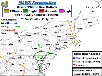
Verification yielded some mixed feelings and results. The end result, without a doubt, yielded enough coverage and amount of reports to warrant a Slight Risk. The fact that I was the only one with a Slight Risk for the better part of the day until early Afternoon when SPC issued a late term Risk upgrade also counts for something. Most of the reports captured in the Slight Risk were on the fringe and located in the northern/western portion. The difference between a so-so and slam dunk end result would have been to capture the 4 hail reports in/around Williamsport with the Slight Risk. As it was, could have probably slightly trimmed back on the south/east extent of Slight Risk, and taken that extra areal coverage and used it to expand a tad north where the 4 hail reports were located, without making the risk area excessively large for the situation, which IMO resembled SPC's outlooks thruout the afternoon.

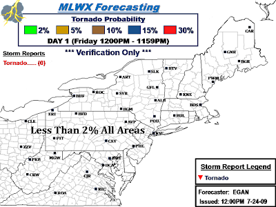
No Tornadoes, not even any warnings, making the tornado threat virtually non-existent Today, which was part the original forecast. SPC did upgrade to a 2% probability for some odd reason with their mid-afternoon update, not sure why.

All in all, certainly not the best I've seen and done before, but can't pass em' all with flying colors.

Total of 17 Severe Weather Reports...

Slight Risk captured 11/17 reports;
15% Severe Wind Probability: Captured 4/4 measured/estimated severe gusts/wind damage reports.
15% Severe Hail Probability: Captured 7/13 severe hail reports.

Isolated Severe captured 6/17 severe weather reports;
5% Severe Wind Probability: Captured 0/4 measured/estimated severe gusts/wind damage reports.
5% Severe Hail Probability: Captured 6/13 severe hail reports.

..EGAN.. 07/25/2009


Discussion...

Update: Severe Weather Outlook for Friday, July 24, 2009...

Discussion...
Just a quick update to the Overnight D1 SWO before I run out here for a little bit. Little bit surprised SPC doesn't have a Slight Risk posted by now for the Delmarva Vicinity into PA/NJ, but with or without their support, going to maintain continuity from previous Overnight Outlook posted above in #56.

Latest RUC supports my forecast from last night which leaned on the 00z NAM, and that is, a corridor of more robust convection development appears to exist this Afternoon/Evening across the Southeast portion of the area where healthy SBCAPE/LI/Shear are co-located. Earlier Slight Risk included Eastern VA/MD/DE, but based on latest RUC, felt risk expansion into Southeastern PA/Southern NJ is warranted. Hence, final outlook will feature an extension of previous Slight Risk, which will continue to carry an equal 15/15 weight for severe hail/damaging wind. RUC also supports the NAM with minimal helicity values, therefore tornado threat will continue to remain below 2%.

..EGAN.. 07/24/2009


Day 1 Severe Weather Outlook for Friday, July 24, 2009...

Discussion...
Overall pattern looks to be a near carbon copy of the previous day. Setup once again features relatively weak wind fields, combined with rich low level Dp's and Pwat's. Hence, favorable environment for slow-moving showers/storms will be in place over a large part of the area once again. Primary threat will be localized flooding with any of the slow movers, so flash flood advisories/warnings seem like a pretty good bet.

In terms of severe, environment fits the profile for pulse-type convection, some of which could briefly attain severe limits with marginally severe hail and perhaps a few damaging wind gusts possible in the strongest cores. Having said that, 00z NAM depicts a rather localized area of modest destabilization and lift coupled with sufficient low level bulk shear values in/around Eastern VA/MD/DE. All things considered, environment looks supportive for a greater coverage of severe storms. Therefore, will try my hand at a localized Slight Risk for severe hail/wind in this area. Given overall small size of the Risk area, will be looking for a concentration of about 7+ combined severe wind/hail reports in this corridor. Lastly, with helicity values progged to be AOB 100 just about everywhere Today, tornado threat should once again be non-existent.

..EGAN.. 07/24/2009


7/23/2009

Day 1 Severe Weather Outlook for Thursday, July 23, 2009...

Discussion...
For Today, the setup looks pretty lackluster to say the least for organized severe storms. Current radar shows large batch of locally heavy rainfall with a few embedded rumbles located along and west of the Appalachians in western sections of the area. With rich Dp’s, high pwat’s, and weak wind fields in place, think the bigger potential Today will surround heavy rainfall and the potential for some flood advisories and/or warnings.

None the less, can’t rule out a few isolated severe storms where pockets of moderate instability are realized during the Afternoon/Evening hours along and ahead of slow moving cold front draped across the Appalachians. Current SPC D2 Outlook looks pretty good based on 00z runs, so wouldn’t expect much change, aside from perhaps tightening up the eastern periphery of current D2 5% probability for upcoming D1 Outlook. To me, it appears best chance for a few brief severe storms with marginally severe hail/damaging wind gusts will be along/west of I-81 across NY/PA, and along/west of I-95 thru VA. Overall, suspect we will see less than 15 severe weather reports on the day.

..EGAN.. 07/23/2009


7/17/2009

Day 1 Severe Weather Outlook Verification for Thursday, July 17, 2009...

Discussion...
Overall, a pretty successful outcome after sifting thru the severe weather reports. Turns out a 15% probability for both severe wind and severe hail was exactly what was needed, nothing more and nothing less. Obviously, it’s quite easy to see the highest concentration of severe weather was across Eastern NY/Western New England, and not in the immediate tri-state. There was also a noticeable cluster of severe reports was in and around the Philadelphia area.

Breakdown… Total of 48 severe weather reports, 22 wind damage reports and 25 severe hail reports, 2 of which were very large (aoa 2.00” in diameter), and 1 Confirmed Tornado.

Slight Risk captured 46/48 severe weather reports;
15% Severe Wind Probability: Captured 21/22 wind damage reports.
15% Severe Hail Probability: Captured 24/25 severe hail reports.
2% Tornado Probability: Captured 1/1 confirmed tornadoes.

Isolated Severe captured 2/48 severe weather reports;
5% Severe Wind Probability: Captured 1/22 wind damage reports.
5% Severe Hail Probability: Captured 1/25 severe hail reports.

Another Severe Weather Event in the M-A/N-E, and another successful Outlook Verification.

..EGAN.. 07/17/2009


7/16/2009

Late Morning Severe Weather Outlook update for Today...

Discussion...
Latest surface observation shows Cold Front draped across the Ohio River northeast to about KERI and KBUF. With that in mind, will update previous outlook and tidy up and tighten up the 5% Severe and Thunder line with OH and far western PA/NY now in the clear. Primary change will be to remove the smaller Slight Risk across the southwest and replace with a Isolated Severe/5% probability.

As Mike alluded too earlier, better dynamics are in place further north into the I-95corridor/Upstate NY/Western New England. Previous Outlook done by Mike looks excellent for this area, and will not tweak anything. Last Night he mentioned the idea of Damaging Wind being the dominant threat over hail, which still looks to be the case, though will still carry an equal 15% to account for any more remote/discrete cells that manage to develop, any of which will increase the severe hail threat, as well as a brief tornado or two. Hence, a 15/15/2 threat looks legit in this area, and will continue as was already forecasted. Previous Discussion below...

..EGAN.. 07/16/2009

Previous Discussion... as of 1:46AM 07/16/2009
I just happen to be at the helm tonight for issuing the map and disco for a change as Logan won't be able to get to the computer for awhile due to a fire call. However, I decided to differ from SPC's broad slight risk and go with a split up 15% slight risk. The NAM shows a notable hole in the CAPEs in PA, MD and northern VA, better dynamics are also found further north. The GFS also shows the same general thing , but the more precise resolution of the NAM is favored for our forecast.

While CAPES and LI are relatively decent in a good portion of the mid-atlantic and northeast, the models are not printing out alot of precip, so the idea here is that thunderstorms will be at a premium, but whatever ones that do develop in the slight risk areas will have a decent chance of being severe. In general, we're looking for wind to be the primary threat but will keep wind/hail threats even at 15%.

EHI values are modest at best and centered along the Eastern NY border infringing into western Mass. and CT and up into Vermont and New Hampshire. A 2% tornado risk was used to encompass the area of enhanced forecast EHI, though the best chances for any tornadic development will likely be further south in the NY Hudson Valley from say.. around Albany southward.

..GLUNT.. 07/16/2009


UPDATE: Day 1 outlook for July 16th, 2009

Discussion...
I just happen to be at the helm tonight for issuing the map and disco for a change as Logan won't be able to get to the computer for awhile due to a fire call. However, I decided to differ from SPC's broad slight risk and go with a split up 15% slight risk. The NAM shows a notable hole in the CAPEs in PA, MD and northern VA, better dynamics are also found further north. The GFS also shows the same general thing , but the more precise resolution of the NAM is favored for our forecast.

While CAPES and LI are relatively decent in a good portion of the mid-atlantic and northeast, the models are not printing out alot of precip, so the idea here is that thunderstorms will be at a premium, but whatever ones that do develop in the slight risk areas will have a decent chance of being severe. In general, we're looking for wind to be the primary threat but will keep wind/hail threats even at 15%.

EHI values are modest at best and centered along the Eastern NY border infringing into western Mass. and CT and up into Vermont and New Hampshire. A 2% tornado risk was used to encompass the area of enhanced forecast EHI, though the best chances for any tornadic development will likely be further south in the NY Hudson Valley from say.. around Albany southward.

..GLUNT.. 07/16/2009

The maps: