4/09/2010

April 8, 2010 Severe Wx Outlook Verification...


Post-game writeup...

Overnight Severe Wx Outlook Verification for 4-8-10...

Total of 47 Severe Wx Reports across Forecast Area;
Wind Damage/Severe Gusts (58mph +) - 44
Large Hail (1.00" Diameter +) - 3
Tornadoes - 0

Hardest Hit County: Broome County NY - 6 Wind Damage reports (Also 2 homes sustained significant damage from lightning strikes). Have to love it when own county experiences the most severe weather of anywhere in the M-A/N-E.

*Slight Risk for Damaging Winds/Severe Gusts ONLY...

15% Damaging Wind/Severe Gust Probability- Captured 40/44 reports
5% Damaging Wind/Severe Gust Probability- Captured 4/44 reports
5% Large Hail Probability- Captured 3/3 Large Hail reports

*No Tornado Probability areas were issued, and 0 tornadoes were officially reported. 1 unofficial tornado report was reported via the public in Broome County NY, although it has been deemed straight-line winds as the likely cause by NWS Binghamton. A couple tornado warnings were issued in far South Central VA near the NC border, and a Tornado Watch was posted, thus, could argue that a Tornado Probability could have been issued over South Central VA.

*Could have made strong case for a 30% Damaging Wind/Severe Gust Probability from South Central PA northeastward into South Central NY based on the # of wind damage reports.

2/15/2010

Winter Storm underway across the Region...


Discussion...

Here is our final post on accumulations. For all intent and purpose, this is the same forecast as the previous with the exception of just a few slight variations, which I will quickly run down here.

#1. Removed previous highlight for isolated 7+ over Northeast PA/East Central NY. QPF has waned just a bit with today’s runs over this area, so we feel comfortable enough that all areas stay at or under 7”.

#2. Tightened up the 3-7” range along northern and southern periphery thru Southeast PA/Eastern and Central NY. The main concern for cutting back just a bit over parts of the Lower Susquehanna Valley is tied to potential for dry slot/lack of QPF. Lack of QPF also main factor to adjustments further north. Debated whether to axe majority of Central PA from 3-7", but will leave as is with intent that most areas see 3-4". This could however end up being too generous given latest trends.

#3. Trimmed northern CT-Northwest RI-Southern MA from 6-12”, and brought this range along and north of the Massachusetts Turnpike. Primary reason for doing this is QPF may be a little bit lighter than previously thought here. That is not to say some areas will not still reach 6-7” here, but the 3-7” range should do the trick here.

#4. Trimmed 6-12” out of southeast Maine and replaced with a highlight for 6+. The theory here is that some areas along the coast may briefly mix and warm aloft which could contribute to lower totals here. Feeling is that most areas within this area will fall between 4-7”, with a few spots just inland from the coast perhaps exceeding 7”.

#5. Extended 3-7" thru the remaining portion of Northern ME. Feeling is most areas here will reach or exceed 3" as SLP cuts off and retrogrades in the vicinity of the Canadian Maritimes providing an extended period of light snow across Northern Maine thru the end of the period (0z Thursday/7PM Wednesday). Terrain is generally >1200ft. across Northern ME, which will also factor in.

..EGAN.. 2/15/10

Another Winter Storm set to move in...


Discussion...

We decided to make no significant changes to our map going forward. Introduced 6-12 range in Ohio getting to the PA border where heavier deformation snow occurs prior to the low reestablishing itself near the coast. Speaking of 6-12 inches, we don't expect to see much in the way of any top amounts over 10 inches anywhere. We also highlighted the Laurel Highlands as well as the area of Northeast PA and Central NY which includes the Poconos and Catskills. Here, expecting many areas to stay within 3-7”, however, a few spots in the higher terrain could exceed 7”.

Once again, I think mixing will not be a major issue outside some immediate coastal locations and I continue to think the track of the low itself will have most of the precipitation situated further inland from folks especially in Philly and NYC, thus resulting in lower precipitation totals.

As always, there are a few concerns that potentially may need future adjustment (IE. Dry Slot/Mixing issues etc.), but we have relatively high confidence in this forecast as is. Any final tweaks will be made following 12z runs before action begins picking up in western zones.

..GLUNT/EGAN.. 2/15/10

2/09/2010

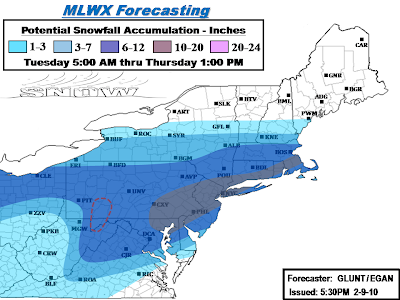
Update: Major Winter Storm underway across the region...


Discussion...
Final call map on our accumulations for this storm. Things have shifted north in the model runs today, putting regions that we orginally had in heavier snow a couple days ago back into it. Decided to adjust things back toward the original in the northern areas in light of these last minute trends.

Other changes we made was to back off the snow once again in West Va. Even though warnings exist in most of the state for 4-8 inches, radar trends don't seem too favorable at current with mostly rain and mixing and coastal development will eventually yank alot of remaining precip northeast when things do changeover. So went with a 1-3 in the southwest half of the state while significantly retreating the 3-7 back toward the 6-12 zone. Speaking of mixing, we also backed the 10-20 inch zone slightly away from the NJ coast and in eastern long island, and also the southern new England coast as some minor mixing on the coast may knock totals down a few inches on the immediate coast. However, mixing in the big cities is expected to be minimal.

In the bullseye region we made the decision to back the 10-20 inch zone to just northeast of the DC area. We feel that the best QPF and ratios are going to lie northeast of DC towards Philly and NYC. However, we do understand that totals are likely going to be on the max end of that 6-12 range there and potentially exeed the range by a couple inches. In other parts of our 10-20, we changed our dashed region on the first map issuance to solid as we should see some pretty consistent 13-14+" reports in NYC and up into southern New England. We also expanded it north and west, back into Harrisburg and up through the Lehigh Valley and southern Pocono's.

Areas to watch:
Central PA, on both ends of the spectrum...
Start of this storm has been sputtery at best today in central PA, things still look fine for 6-12 inches but evolution of the coastal should be watched. If the coastal throws back a few significant bands then could see totals higher than 12 inches. However, the handoff process also has the chance to make for some lower totals.. but should still make it to at least 6 inches.

DC, already mentioned above.. going a bit conservative compared to others, but we feel that the best of the storm will hit Philly northeast.

New England: Boston may well just back themselves into quite a snow event after all.. we have them progged in the 6-12 zone in our new map, and if things shift a bit more north and/or linger, we could even see that go up a bit.

..GLUNT.. 2/9/10