Discussion...
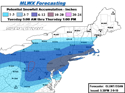
Final call map on our accumulations for this storm. Things have shifted north in the model runs today, putting regions that we orginally had in heavier snow a couple days ago back into it. Decided to adjust things back toward the original in the northern areas in light of these last minute trends.
Other changes we made was to back off the snow once again in West Va. Even though warnings exist in most of the state for 4-8 inches, radar trends don't seem too favorable at current with mostly rain and mixing and coastal development will eventually yank alot of remaining precip northeast when things do changeover. So went with a 1-3 in the southwest half of the state while significantly retreating the 3-7 back toward the 6-12 zone. Speaking of mixing, we also backed the 10-20 inch zone slightly away from the NJ coast and in eastern long island, and also the southern new England coast as some minor mixing on the coast may knock totals down a few inches on the immediate coast. However, mixing in the big cities is expected to be minimal.
In the bullseye region we made the decision to back the 10-20 inch zone to just northeast of the DC area. We feel that the best QPF and ratios are going to lie northeast of DC towards Philly and NYC. However, we do understand that totals are likely going to be on the max end of that 6-12 range there and potentially exeed the range by a couple inches. In other parts of our 10-20, we changed our dashed region on the first map issuance to solid as we should see some pretty consistent 13-14+" reports in NYC and up into southern New England. We also expanded it north and west, back into Harrisburg and up through the Lehigh Valley and southern Pocono's.
Areas to watch:
Central PA, on both ends of the spectrum...
Start of this storm has been sputtery at best today in central PA, things still look fine for 6-12 inches but evolution of the coastal should be watched. If the coastal throws back a few significant bands then could see totals higher than 12 inches. However, the handoff process also has the chance to make for some lower totals.. but should still make it to at least 6 inches.
DC, already mentioned above.. going a bit conservative compared to others, but we feel that the best of the storm will hit Philly northeast.
New England: Boston may well just back themselves into quite a snow event after all.. we have them progged in the 6-12 zone in our new map, and if things shift a bit more north and/or linger, we could even see that go up a bit.
..GLUNT.. 2/9/10
No comments:
Post a Comment