8/09/2009

Updated Severe Weather Outlook for this Afternoon/Evening...

Final Outlook is here. Two changes to previous outlook. First was to slighty extend Slight Risk/15% probability a bit to the southeast to account for fallout of current MCS over Western NY. The WRF appears to have been right on the money with developing a large Bow Echo, and tracking it into Western NY by 18z. It hinted at this Bow holding together into atleast East Central PA, so will match this up with current 30%Damaging Wind probability that was issued last night.

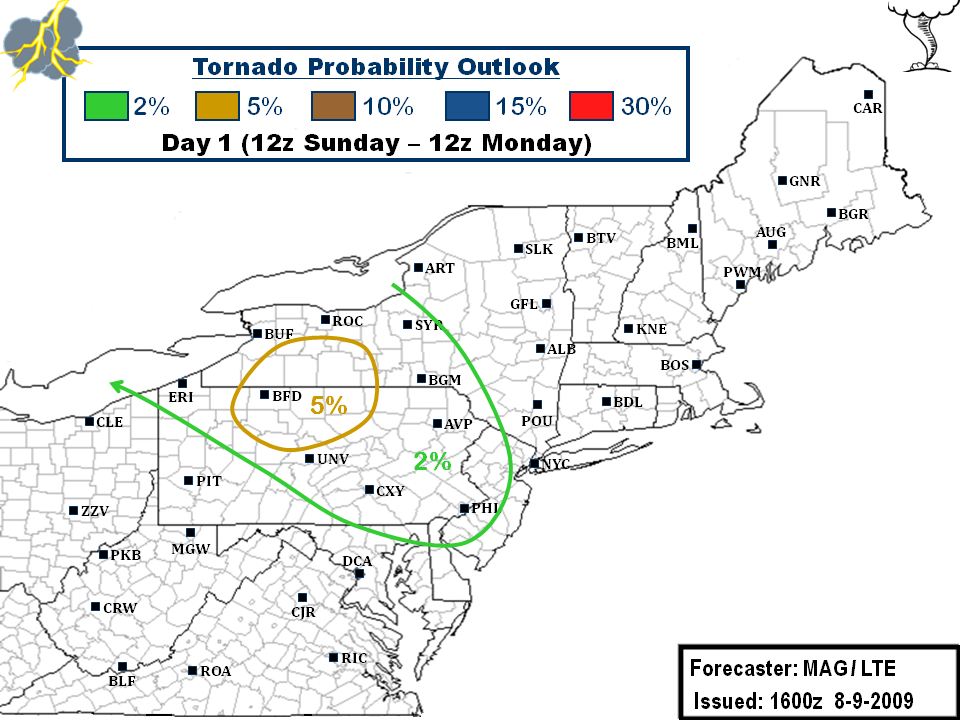
Last change, after some good discussion, we decided to hoist a 5% Tornado probability for parts of Western/Central NY and North Central PA. I have reasonable confidence that in front of this nasty line of severe weather that we can get some cells to fire out ahead. This region roughly encompasses where it has essentially cleared out as evidenced by the visible pic:


This area of clearing is along the warm front and just south of it in the warm sector, where the heating and high dewpoints and associated CAPES and some reasonable shear would make any storm development out ahead have a high probability of becoming severe. Additionally, the line itself could also have some shenanigans up its sleeve once it crashes south. We're going a lil bit more heightened on the tornado threat, but I think its something to watch.

..GLUNT/EGAN.. 08/09/2009


Discussion...

Overnight Severe Weather Outlook for Sunday, August 9, 2009...

Discussion...
As mentioned, probabilities are capped at 30/15/2 for Damaging Wind, Large Hail, and Tornadoes, respectively.

Current thinking is that by Mid-morning, Western NY into Northwestern PA should begin to see some clearing from current cloudiness/precipitation moving thru. This should allow for ample enough destabilization to occur here by mid-Afternoon and support thunderstorm re-development by 18z. While at first, storms may be somewhat loosely organized, think we could see a quick transition into a more linear configuration, possibly a bow echo, that will track east-southeast from Western NY into north central PA, and points southeast. For this reason, cashed in previous D2 30% coverage probability for an enhanced 30% Damaging Wind probability that will span from Western NY to East Central PA. It should be noted that the 00z WRF shows what could be a powerful bow echo tracking over this 30% Damaging Wind corridor. So, bottomline, think Damaging straight-line winds will be the primary threat, with Large Hail a secondary threat.

Despite a somewhat favorable environment for a few isolated tornadoes, overall convective mode should feature more in the way of bows/segments/clusters and associated damaging wind threat. The tornado threat is somewhat conditional on the question as to whether any discrete supercells can develop aside from any organized lines/bows. As mentioned earlier, as the Afternoon progresses, feeling is that on-going convection, if it hasn't already, will transpire into an organized MCS of sorts that tracks into PA by Evening, before weakening as it reaches the Lower Susquehanna Valley.

I'll will surely re-analyze things later this Morning when the RUC becomes of relevent use. I don't plan on lowering any probabilities at this point, so biggest potential change, if there was any, would be to possibly leverage a corridor of 5% Tornado probability. Other than that, I have fairly good confidence in this current outlook verifying to my liking.

..EGAN.. 08/09/2009


8/08/2009

Day 2: Sunday Aug. 9th Severe potential

Discussion...
It looks to be shaping up to potentially be a bit of a noisy day for most of upstate New York and extreme northern PA. Personally i think the more widespread general severe day could be Monday, but the models are printing out impressive parameters for Sunday's smaller impact area...namely the EHI values which are pretty high in the vicinity of the shortwave that will be running the frontal boundary. Further south into PA and so forth, warm temps aloft associated with the ridge punching up will generally cap the atmosphere pretty well. Although, far eastern PA into New Jersey needs to be watched as well, even though their not really included in our severe risk zone...as good parameters sneak down into that region as well. Otherwise, these folks will have their shot Monday. However, the EHI values are not projected to be nearly what they supposed to be on Sunday.

Anyways, we have inserted a 30% coverage region roughly centered over the western part of New York. I'm pretty confident in the fact that we could get a pretty decent outbreak there, and not just because Logan has been ridiculously lucky in getting some good storms to chase and film. Being that this is the first stretch of summer-time weather we have had well... all summer.. theres going to be a ton of moisture and heat available to fuel these storms, as evidenced by the very high capes and PWAT values. Add into that the shortwave moving across which will serve as the trigger. EHI values top into the 2-3 range, which is rather impressive.

I expect storm coverage to generally be cellular and/or bow segments. Storms that develop in the 30% region and probably most of the 15% region will easily have the chance to become severe. This is of course the prelim D2 outlook, and Myself and/or Logan will adjust our outlook accordingly for D1. If things hold, the 30% region will include our more heightened 5% tornado prob.

Severe D2 risk map:


Coverage map:


EHI bullseye:21z Sunday:


0z Monday:


..GLUNT.. 08/08/2009

8/05/2009

Updated Severe Weather Outlook for This Afternoon/Evening, August 5, 2009...

Updated discussion... as of 12:35PM 08/05/2009
I'll be the first to admit that this may not pan out, but for the most part, going to keep with overnight outlook, with a couple minor adjustments. First was to tighten up the General Thunderstorm/Severe probabilities to match latest frontal placement, as some areas are now in the clear. Decided to keep the 15% Damaging Wind probability in place, but extend it to the southwest thru Eastern New England. Last tweak was to contract the minimal tornado probability, and relegate it to southwestern ME where a modest pocket of helicity will be in place, as evident by this morning's RUC13 analysis, which could lead to a brief spin up if any discrete cells can develop in this corridor.

Current and forecasted instability for this Afternoon is plenty strong enough, as well as Negative LI, which will help to offset some of the other lacking ingredients. Effective low level shear will be in the 20-30 kt. range in the southern portion of the risk area, with up to 50 kts in the north. Latest radar shows storms beginning to fire over the higher terrain of western New England, and expect this trend to continue. Damaging winds should be the primary threat, along with an isolated hail threat.

Previous Discussion below...

..EGAN.. 08/05/2009
*****************************************************
Discussion... as of 2:00AM 08/05/2009
General thunderstorms will be possible along and south/east of a line from approximately Saranac Lake NY- Syracuse NY- Bradford PA. A Slight Risk for severe storms will be possible across Downeast ME and extreme eastern NH/MA.

On-going storms over Western NY down to adjacent northeastern OH will begin the outlook period. As stated earlier, despite ample destabilization and lift over parts of the forecast area, weak low level shear will hinder much in the way of storm coverage and organization. 00z WRF showing very little in the way of storms firing along and out ahead of the front Today over much of the area, likely due to the lack of large scale forcing and shear.

Axis of strong shear will be over northern New England, and this is where a 15% Slight Risk will be carried for Damaging wind potential. 00z WRF shows a organized line of convection firing in central ME by early Afternoon and working across the southeastern half of the state thru Early Evening. Thus, think damaging winds will be the primary threat in this area. Debated whether to tack a low 2% tornado probability with this potential, and did so with the idea there could be a brief spin-up if any embedded supercell structures emerge within the line.

Elsewhere, only other area of organized convection is shown to be over the southwest, across parts of WV eastward into VA. However, lack of low level shear will preclude any higher probabilities than 5% for wind/hail for now. Not out of the question that may need to re-visit this potential later this Morning with final outlook issuance.

..EGAN.. 08/05/2009


Severe Weather Outlook for Wednesday, August 5, 2009...

Discussion... as of 2:00AM 08/05/2009
General thunderstorms will be possible along and south/east of a line from approximately Saranac Lake NY- Syracuse NY- Bradford PA. A Slight Risk for severe storms will be possible across Downeast ME and extreme eastern NH/MA.

On-going storms over Western NY down to adjacent northeastern OH will begin the outlook period. As stated earlier, despite ample destabilization and lift over parts of the forecast area, weak low level shear will hinder much in the way of storm coverage and organization. 00z WRF showing very little in the way of storms firing along and out ahead of the front Today over much of the area, likely due to the lack of large scale forcing and shear.

Axis of strong shear will be over northern New England, and this is where a 15% Slight Risk will be carried for Damaging wind potential. 00z WRF shows a organized line of convection firing in central ME by early Afternoon and working across the southeastern half of the state thru Early Evening. Thus, think damaging winds will be the primary threat in this area. Debated whether to tack a low 2% tornado probability with this potential, and did so with the idea there could be a brief spin-up if any embedded supercell structures emerge within the line.

Elsewhere, only other area of organized convection is shown to be over the southwest, across parts of WV eastward into VA. However, lack of low level shear will preclude any higher probabilities than 5% for wind/hail for now. Not out of the question that may need to re-visit this potential later this Morning with final outlook issuance.

..EGAN.. 08/05/2009


8/04/2009

Updated Severe Weather Outlook for This Afternoon/Evening, August 4, 2009...

Updated Discussion... as of 12:45PM 08/04/2009
Still some uncertainties regarding severe potential this Afternoon/Evening. All in all, not going to change much at all from previous outlook, and whatever happens I’ll live with.

Currently 2 MCS systems on-going. The first was on-going over parts of eastern KY/southern WV, and getting set to move into southwestern VA. Activity has shown a gradual weakening trend over the past several hours as activity encounters a less supportive environment, with no warnings/reports to show for in the past few hours.

A second, more potent MCS was located upstream near the IL/IN border as of this writing. Severe weather is occurring all along this line, with widespread wind damage reports thru central IL. Current SPC meso-analysis shows a much more stable environment near the IN/OH border out ahead of this line. Both the WRF/NAM show this MCS losing it’s punch and weakening across IN, before reaching the far western portion of the area. Hence, continue to think best chance for severe weather will have to come from storm development out of ahead of the front later this Afternoon/Evening as organized convection upstream weakens and slips south/west of the area.

This Mornings NAM12/RUC13 simulated reflectivity continue to hint at storms firing from southern Ontario to northern WV by mid-Afternoon, and moving east into western NY/PA by Evening hours. Here the environment has been untouched by previous convective remnants from the Overnight thru this Morning, so convective parameters should be somewhat supportive for severe, with the best window of opportunity from 4PM-9PM. However, a second line of convection is shown to originate over southern Ontario, and move in off Lake Erie from roughly KCLE to KROC by 11PM. Not out of the question, depending on how previous convective schemes play out later this Afternoon/Evening, that some severe could linger across the Slight Risk area up until the end of the outlook period, or 12AM Wednesday.

Previous Discussion below...

..EGAN.. 08/04/2009

********************************************
Discussion... as of 2:30AM 08/04/2009
Overall conditions will be favorable for general thunderstorms along and west of line from approximately Caribou ME- Portland ME- Hartford CT. A Slight risk will be in affect across parts of NY/PA/WV/MD.

Rather complex outlook is in store for Today. 00z WRF shows a rather potent MCS developing Tonight over Southern IN and continuing Southeast toward the western edge of the forecast area. The bulk of the action looks to stay west of the area, primarily from Southern IN/Central KY, and points south and west.

Despite favorable SBCAPE and Negative LI across much of the western areas, best low level shear values will remain north of the border in Canada and northern MI for the most part. 00z WRF depicts a noticeable split in the action between the aforementioned MCS and the area of thunderstorm development later this Morning/Early Afternoon.

If this ends up being the case, best chances for severe weather appear to be along the Ohio River from OH/WV border and points north/east from 3 PM onward. Overall storm mode looks to favor a more linear assortment and multi-cellular clusters, however, there is a chance for a couple supercells. Hence, an equal 15% hail probability, and minimal 2% tornado probability will also be included. All in all, there is certainly a chance that things will need adjustment later this Morning.

..EGAN.. 08/04/2009


Severe Weather Outlook for Tuesday, August 4, 2009...

Discussion... as of 2:30AM 08/04/2009
Overall conditions will be favorable for general thunderstorms along and west of line from approximately Caribou ME- Portland ME- Hartford CT. A Slight risk will be in affect across parts of NY/PA/WV/MD.

Rather complex outlook is in store for Today. 00z WRF shows a rather potent MCS developing Tonight over Southern IN and continuing Southeast toward the western edge of the forecast area. The bulk of the action looks to stay west of the area, primarily from Southern IN/Central KY, and points south and west.

Despite favorable SBCAPE and Negative LI across much of the western areas, best low level shear values will remain north of the border in Canada and northern MI for the most part. 00z WRF depicts a noticeable split in the action between the aforementioned MCS and the area of thunderstorm development later this Morning/Early Afternoon.

If this ends up being the case, best chances for severe weather appear to be along the Ohio River from OH/WV border and points north/east from 3 PM onward. Overall storm mode looks to favor a more linear assortment and multi-cellular clusters, however, there is a chance for a couple supercells. Hence, an equal 15% hail probability, and minimal 2% tornado probability will also be included. All in all, there is certainly a chance that things will need adjustment later this Morning.

..EGAN.. 08/04/2009