"Your #1 Northern Mid-Atlantic and Northeast Severe Weather & Winter Storm Specialists"
10/05/2010
7/21/2010
5/06/2010
4/16/2010
4/09/2010
April 8, 2010 Severe Wx Outlook Verification...
Post-game writeup...
Overnight Severe Wx Outlook Verification for 4-8-10...
Total of 47 Severe Wx Reports across Forecast Area;
Wind Damage/Severe Gusts (58mph +) - 44
Large Hail (1.00" Diameter +) - 3
Tornadoes - 0
Hardest Hit County: Broome County NY - 6 Wind Damage reports (Also 2 homes sustained significant damage from lightning strikes). Have to love it when own county experiences the most severe weather of anywhere in the M-A/N-E.
*Slight Risk for Damaging Winds/Severe Gusts ONLY...
15% Damaging Wind/Severe Gust Probability- Captured 40/44 reports
5% Damaging Wind/Severe Gust Probability- Captured 4/44 reports
5% Large Hail Probability- Captured 3/3 Large Hail reports
*No Tornado Probability areas were issued, and 0 tornadoes were officially reported. 1 unofficial tornado report was reported via the public in Broome County NY, although it has been deemed straight-line winds as the likely cause by NWS Binghamton. A couple tornado warnings were issued in far South Central VA near the NC border, and a Tornado Watch was posted, thus, could argue that a Tornado Probability could have been issued over South Central VA.
*Could have made strong case for a 30% Damaging Wind/Severe Gust Probability from South Central PA northeastward into South Central NY based on the # of wind damage reports.
4/08/2010
4/06/2010
2/15/2010
Winter Storm underway across the Region...
Discussion...
Here is our final post on accumulations. For all intent and purpose, this is the same forecast as the previous with the exception of just a few slight variations, which I will quickly run down here.
#1. Removed previous highlight for isolated 7+ over Northeast PA/East Central NY. QPF has waned just a bit with today’s runs over this area, so we feel comfortable enough that all areas stay at or under 7”.
#2. Tightened up the 3-7” range along northern and southern periphery thru Southeast PA/Eastern and Central NY. The main concern for cutting back just a bit over parts of the Lower Susquehanna Valley is tied to potential for dry slot/lack of QPF. Lack of QPF also main factor to adjustments further north. Debated whether to axe majority of Central PA from 3-7", but will leave as is with intent that most areas see 3-4". This could however end up being too generous given latest trends.
#3. Trimmed northern CT-Northwest RI-Southern MA from 6-12”, and brought this range along and north of the Massachusetts Turnpike. Primary reason for doing this is QPF may be a little bit lighter than previously thought here. That is not to say some areas will not still reach 6-7” here, but the 3-7” range should do the trick here.
#4. Trimmed 6-12” out of southeast Maine and replaced with a highlight for 6+. The theory here is that some areas along the coast may briefly mix and warm aloft which could contribute to lower totals here. Feeling is that most areas within this area will fall between 4-7”, with a few spots just inland from the coast perhaps exceeding 7”.
#5. Extended 3-7" thru the remaining portion of Northern ME. Feeling is most areas here will reach or exceed 3" as SLP cuts off and retrogrades in the vicinity of the Canadian Maritimes providing an extended period of light snow across Northern Maine thru the end of the period (0z Thursday/7PM Wednesday). Terrain is generally >1200ft. across Northern ME, which will also factor in.
..EGAN.. 2/15/10
Another Winter Storm set to move in...
Discussion...
We decided to make no significant changes to our map going forward. Introduced 6-12 range in Ohio getting to the PA border where heavier deformation snow occurs prior to the low reestablishing itself near the coast. Speaking of 6-12 inches, we don't expect to see much in the way of any top amounts over 10 inches anywhere. We also highlighted the Laurel Highlands as well as the area of Northeast PA and Central NY which includes the Poconos and Catskills. Here, expecting many areas to stay within 3-7”, however, a few spots in the higher terrain could exceed 7”.
Once again, I think mixing will not be a major issue outside some immediate coastal locations and I continue to think the track of the low itself will have most of the precipitation situated further inland from folks especially in Philly and NYC, thus resulting in lower precipitation totals.
As always, there are a few concerns that potentially may need future adjustment (IE. Dry Slot/Mixing issues etc.), but we have relatively high confidence in this forecast as is. Any final tweaks will be made following 12z runs before action begins picking up in western zones.
..GLUNT/EGAN.. 2/15/10
2/09/2010
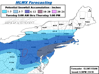
Update: Major Winter Storm underway across the region...
Discussion...
Final call map on our accumulations for this storm. Things have shifted north in the model runs today, putting regions that we orginally had in heavier snow a couple days ago back into it. Decided to adjust things back toward the original in the northern areas in light of these last minute trends.
Other changes we made was to back off the snow once again in West Va. Even though warnings exist in most of the state for 4-8 inches, radar trends don't seem too favorable at current with mostly rain and mixing and coastal development will eventually yank alot of remaining precip northeast when things do changeover. So went with a 1-3 in the southwest half of the state while significantly retreating the 3-7 back toward the 6-12 zone. Speaking of mixing, we also backed the 10-20 inch zone slightly away from the NJ coast and in eastern long island, and also the southern new England coast as some minor mixing on the coast may knock totals down a few inches on the immediate coast. However, mixing in the big cities is expected to be minimal.
In the bullseye region we made the decision to back the 10-20 inch zone to just northeast of the DC area. We feel that the best QPF and ratios are going to lie northeast of DC towards Philly and NYC. However, we do understand that totals are likely going to be on the max end of that 6-12 range there and potentially exeed the range by a couple inches. In other parts of our 10-20, we changed our dashed region on the first map issuance to solid as we should see some pretty consistent 13-14+" reports in NYC and up into southern New England. We also expanded it north and west, back into Harrisburg and up through the Lehigh Valley and southern Pocono's.
Areas to watch:
Central PA, on both ends of the spectrum...
Start of this storm has been sputtery at best today in central PA, things still look fine for 6-12 inches but evolution of the coastal should be watched. If the coastal throws back a few significant bands then could see totals higher than 12 inches. However, the handoff process also has the chance to make for some lower totals.. but should still make it to at least 6 inches.
DC, already mentioned above.. going a bit conservative compared to others, but we feel that the best of the storm will hit Philly northeast.
New England: Boston may well just back themselves into quite a snow event after all.. we have them progged in the 6-12 zone in our new map, and if things shift a bit more north and/or linger, we could even see that go up a bit.
..GLUNT.. 2/9/10
Major Winter Storm moving into the Region...
Discussion...
Overall not many changes were needed from our preliminary scenario map. Biggest overall change was backing off some with accumulations on the northern side. Most difficult aspect of the forecast was deciding on accumulation ranges. This storm will not produce the insane totals the one a few days ago did and generally accumulations over 20 inches will probably be more of an exception rather than rule. With that said, there is liable to be a lot of folks seeing about a foot plus with this storm.. which is still a big storm. Installed a 12-20 inch range from around DC through north central New Jersey, transitioning to a dashed 12-20 from NYC north, as it currently appears that the NYC area and northeastward is looking at more of an 8-14 inch type snowfall with some higher totals here and there. To remind folks, our dashed ranges are installed if we expect to see scattered totals that end up higher than the filled range in that area. In addition we installed a dashed 20-24" centered on Philly and surrounding areas, which is where models have been consistently throwing a QPF bullseye.
What this system "lacks" in snowfall accumulations compared to the last one will make up for it in sheer dynamics. This will be a much more powerful coastal storm and conditions in the I-95 corridor centered on Philly, but also New Jersey, Delaware, eastern MD, DC, and NYC/LI are going to be severe at the height of this storm with the winds it will generate. As the storm moves up and away from the coast, southern New England is probably going to see similar conditions
Further northwest, there is going to be a lot of 6-12 inch amounts across the southern 2/3rd of PA. Installed a dashed 10-20 inch range in the laurel highlands where a couple higher totals are likely to come in. Back in Ohio, looking at probably mainly 5-10 inches in the northern half of the state. Some question of whether a dry slot is going to cut into snow totals especially in southern Ohio, so decided to run with the 3-7 range there.
Things to watch for:
Three words, underdone forecast totals...
We feel that the region we have marked as ground zero is in good shape and covered well with our ranges, however my biggest area of concern is back across the rest of PA. As NWS State College had alluded to, coastal low development and associated mesoscale banding, etc is a big wildcard. Snow ratios is the other wildcard, high snow ratios could result in higher totals as well. Northern fringes are another area to watch, as a last minute northern trend could send advisories and possibly warnings another tier of counties or so north in the northeast.
Blizzard conditions:
I expect NWS offices, especially Mount Holly to issue blizzard warnings at some point today with the wind likely to be a major issue. Further west, it will get windy behind this storm. While it likely won't be really blizzard conditions, there is going to be about a 2-3 foot snowpack to drift around.. and there is liable to be significant problems on roadways with blowing and drifting.
..GLUNT.. 2/9/10
2/08/2010
Another Major Winter Storm on tap this week...
Discussion...
As promised, here is the full disco and a reissuance of our scenario map:
A quick turnaround from the storm that slammed the Mid-Atlantic region over the weekend, this next storm looks to affect some of the same areas as well as places further north this time. Most of the 0z suite is in fairly reasonable agreement with the overall evolution with a low to the Ohio Valley giving way to potentially rapid coastal development of the Mid-Atlantic. The global models/ensembles of the GFS and Euro were given more weight over the NAM which can be too dry with these type of systems.
Unlike most events this winter, this storm is likely to significantly affect the entire I-95 corridor from DC to Boston. The area from Philly to NYC could be the region that gets the most, which would be an unprecedented event for the folks in Philly if they were to get slammed with another major snowstorm. Back west, the primary cutting up into the Ohio Valley and associated transfer to the coast should make for a nice shield of snow to roll through pretty much all of PA, southern NY at least up to or near I-90, northern/western MD and Va, DC, New Jersey and southern New England. As such, we painted this region in a broad heavy swath (>6" potential). Mixing issues could crop up in West Va and extreme SW PA before the coastal low really begins to take over. There will also likely be some mixing in southeast VA and the southern Delmarva regions.
The biggest single issue at the moment is how deep and rapidly is the coastal going to form. If the 0z Euro had its way with an impressively deep 974 low, it would probably give Philly a storm similar to what they just saw, and clobber most of the eastern half of pa up through southern New England. Other issues especially for folks to the west will be the snow ratios, which are liable to be high with this system due to the cold air that is going to have to work with. At this point, folks in far upstate New York and northern New England appear that they will have minimal or no impacts from this storm.
..GLUNT.. 2/8/10
2/05/2010
Updated: Final Accumulations for the Feb 5-7th Storm...
Discussion...
We made a few slight adjustments here and there with regards to accumulations. In the ground zero zone, we combined the two separate dashed areas of 24-32" to encompass DC and Baltimore, where there is liable to be some 28-30 inch amounts in their western suburbs. We also bumped up the upper bound to 36 inches for the dashed area to account for the mountain locations in the zone. Would not be at all surprised to see someone in the apps to even see more than that.
Other changes we made was to bring the 12-24 range slightly higher into PA, now cutting into the second tier of counties. Additionally we took a couple counties in WV out of the 12-24 range due to some mixing issues, but didn't go too crazy with the axe there. Those areas should turn over to all snow and still get significant snow.
Keeping an eye on...
NYC metro: We have most of NYC proper in our 3-7 range, and attm that looks like a good call. Very tough forecast, things could go either way in that city.
The rest of southern PA under I-80 (western) and I-78 (eastern): Theres still a chance that the very heavy stuff makes better penetration into these areas for at least a time and makes for amounts that could get somewhat comparable to further south.. especially if significant banding sets up with potentially better ratios.
..GLUNT.. 2/5/10
February 5-7, 2010 Major Winter Storm...
Discussion...
All in all, very minimal fine tuning was done when we upgraded from the scenario to accumulations. They were translated as follows... Light (1-3), Moderate (3-7), Heavy (6-12, 12-24, isolated 24-32).
Just a couple of quick points...
Central Appalachians/Northern Delmarva/Southern NJ… As mentioned, highlighted 2 areas where localized amounts may exceed 2 feet. This would be over the Central Appalachians, including much of the Blue Ridge, in West Virginia, Virginia, Maryland. This was due in large part to the high terrain of this area. The other area is across the northern Delmarva area of Maryland, Delaware, and also includes southern New Jersey. Feeling is that this area is most vulnerable to experience some rather intense meso-banding as coastal low begins to take over and rapidly deepen. High winds are also likely at the height of the storm here which will only exacerbate the situation. In either of these areas, most locals will stay under 24", however, potential exists for isolated amounts higher than this, perhaps exceeding the 30” mark.
Southeast Virginia… Most noticeable change from earlier was to bring moderate accumulations of 3-7” further southeast in the Tidewater region of Virginia. Even though this area will experience quite a bit of mixing, with even some plain rain possible at times earlier on, feeling is that all areas will change to snow toward the final 6 hours of the event as the coastal low deepens off the North Carolina coast and deformation snows work into the area. Highest amounts of 3-7” will be found away from the coast.
NYC/LI… Continued with the idea that most significant snow stays south into Central New Jersey. Going with 1-3” across northern suburbs/boroughs, and much of Long Island. Did however bring 3-7” into Staten Island and extreme southern Nassau County LI. This is still a very tough call, and to be honest, even a slight shift in either direction (North or South) could affect accumulations significantly.
In addition, here is a small list of cities that I’ve decided to take a stab at an official accumulation projection on…
State College, PA- 6”
Richmond, VA- 7”
Parkersburg, WV- 8”
Pittsburgh, PA- 9”
Harrisburg, PA (Capital City)- 10”
Roanoke, VA- 12”
Morgantown, WV- 13”
Philadelphia, PA- 14”
Washington, D.C- 20”
Baltimore, MD- 22”
Dover, DE- 24”
..EGAN.. 2/5/10
2/04/2010
Update: Major Winter Storm likely Friday into Sunday...
Discussion...
We've expanded the axis of heavy area a little bit from the original that was issued a few days ago with the increasing confidence of where the axis of heaviest snows (>6") will be located. However, trends for the extreme northern fringes in places near the NY/PA border over to southern New England have not been stellar, and we're backing off just a little bit in those areas, however, we still think lighter snows will reach into coastal southern New England.
At this point confidence is very high that southern PA, southern New Jersey, and OF COURSE the golden child region (Northern Virginia into the Baltimore/Washington corridor) are going to experience the heaviest snowfall. In this area, potential exists for 10 or more inches.
The area with the least confidence is Northeast Pennsylvania and Southeast New York, including the NYC metro. For now, we have maintained continuity from previous outlook and with moderate accumulations (under 7”) spreading into NYC, however, axis of heavier snows lies just to the south across Central New Jersey. Hence, it won’t take much of a shift to the north to bring heavier totals into NYC. Needless to say, there will be a fairly tight accumulation gradient in the Tri-State. Back to the west, low confidence as well for the I-80 corridor and immediately north across Pennsylvania, where aforementioned tight gradient could make for amounts ranging anywhere from a warning snowfall in excess of 6” to a meager 1-3” event depending on track adjustment.
The official accumulation outlook will be forth coming from us later today. At the present time, current thinking is will probably upgrade these zones to the following... Light (1-3), Moderate (3-7), Heavy (6-12/12-24).
..GLUNT/EGAN.. 2/4/10
2/03/2010
Update: February 5-7, 2010 Potential Winter Storm...
Discussion... Updated 3:30AM 2/3/10...
Initially had planned on issuing update to previous scenario outlook that was issued 24 hours ago by Mike, with the main emphasis surrounding the idea of shifting axis’ further north based on latest model trends from the day. This northern trend was being led primarily by the GFS/NAM/GFS Ensembles, which have advertised the most noticeable northward shift throughout the course of the day.
However, latest runs of the Canadian/Euro, namely the Canadian, which up until this Evening’s 0z run seemed to be one of, if not the most consistent operation model thus far regarding this event, have thrown a bit of a wrench into the situation. It’s been made widely known that reconnaissance data from the Pacific has now been ingested by the American models, whereas their foreign counter-parts remain unaffected by this data. How significant this facet of information has made a difference in the model output remains to be seen, but it is quite intriguing and worth noting that the American models tend to lie on the northern envelope of the guidance, whereas the Foreign models tend to reside on the southern end as far as QPF is concerned. The main culprit behind this QPF discrepancy will depend on the evolution of the LP system and whether or not a primary LP can penetrate further north into the OV before transferring its energy to the coast. The GFS/NAM delay this handoff the longest, and consequently bring the significant snow further north as opposed to a more Canadian/Euro which takes main LP to the coast much sooner.
This discrepancy among the models has the most significant implications on areas such as Ohio, Western Pennsylvania, and areas north of about I-80 up to about the NY/PA border over to the Massachusetts Turnpike. If the GFS/GEFS/NAM are correct, this region would be subject to a significant winter storm, whereas if current Canadian/Euro evolution is correct, these areas would be spared a significant event, with the best snows passing south of the area.
Having said that, enough uncertainly exists such that we feel best course of action is to remain consistent with previous forecast. We feel the current forecast offers up a logical “middle of the road” approach” to the current model spread, and thus, will re-run previous scenario outlook for at least another period, and await further runs during the day on Wednesday before making any significant changes.
..EGAN.. 2/3/2010
2/02/2010
Feb 5-7, 2010 Potential Winter Storm...
Discussion...
Here is the preliminary scenario map for the storm. Being that its still about a D4-D5 event, I'm obviously going to go with the disclaimer of "subject to change". Both Logan and I look to issue a coordinated followup scenario on Wednesday when things are getting into that realm of being much more certain.
I used the basis of my axis' shape on the evolution of the precipitation shield on the high-res RGEM precip map and shifted the axis southeast some which accommodates the current model suite. Otherwise I think this storm will evolve in a miller-B type fashion with a primary in the Ohio Valley giving way to the secondary coastal storm. That will knock down snow totals in the far southwestern part of VA/WV and eastern KY.
While I used the RGEM precip map to form a basic shape, I'm not quite sure I buy how warm it is at this juncture in VA. So the moderate region is pushed further southeast into the central VA region. Once to about Richmond though on the I-64 corridor, I do think mixing will be a bit more of an issue this go around for those folks as well as up into the southern Delmarva.
Overall, I'm definitely on the further north train with this storm. And there's a decent chance that the northern trend isn't done. The PV should be more to the east for this event and there is not a fresh arctic airmass drilled all the way into the Carolinas. That by default tells me this is coming higher than the last storm. However, that extremely deep storm blocked up north is going to eventually send this low to a more easterly trajectory and likely keep most of upstate New York and New England out of the storm, again.
..GLUNT.. 2/2/10
1/29/2010
January 29-31, 2010 Mid-Atlantic Winter Storm...
Discussion...
Here is the final snow map for the storm. For the folks that saw our scenario map last night, we essentially made no deviations on it and went with the traditional 1-3, 3-6, and 6-12 ranges. Models remain in good agreement with respect to precipitation area placement and QPF. The GEFS and NAM place the heaviest QPF along the NC/VA border, with potential for between 1.25-1.50. It is here we decided to opt for placement of an isolated higher zone of 12-16 (for the potential of a few locations getting over a foot), but overall, still expecting most locations to fall within the range of 6-12.
Potential Issues:
First... Precipitation shield placement and track remains the main issue with respect to northern extent. Our map involves DC on the edge of 1-3 inches, while leaving Baltimore outside this range with the idea they stay under an inch. It continues to be a possibility that the precipitation shield penetrates further north bringing light accumulations north of a line from D.C. to Cape May County NJ, however given the amount of cold and dry air in place, we expect precipitation to have a very hard time reaching the ground with only light QPF forecasted to reach this area. Hence, we think amounts stay under an inch, however, will need to keep an eye today on the high-res models and radar trends.
Second... Another possible issue if the storm does come a bit further north would be dry slotting knocking storm totals down in the southern parts of the accumulation area, as the main deformation axis would set up further north. In addition, this would also increase the potential for some sleet to mix in across the far south, which would also slightly lower amounts. At the present time, think the only area that stands a chance at mixing is across immediate coastal areas near the vicinity of Virginia Beach.
Other than the slight possibility of either of these issues, this continues to be a high confidence forecast by us, with very little change implemented from 24 hours ago.
..GLUNT/EGAN.. 1/29/10
1/07/2010
January 7-8, 2010 Clipper Event...
Discussion...
Synoptic Event: Once again, up until the latest runs, models the last several days look to have underestimated QPF amounts for this clipper and that means that we will be going with a more aggressive map. This storm should also feature favorable dendritic growth of the snow so will likely need to factor in the snow ratios which should be above 10:1 for most everyone that sees meaningful snow from this. Back into the higher ground of PA/WV/NY, ratios could be up around 20:1.
The big issue to watch for is the integrity of the snow shield as it gets over the Apps. We still incorporate downsloping but still give a pretty solid 1-3 to folks east of the mountains. If the snow shield holds together well, we could be looking at the solid 3-5 advisory snows continuing eastward to the coast. Given the overall dynamics and strength of this upper level low, it’s something that is plausible.
Accumulations will generally be on the light side to the east of the mountains, with a broad area of 1-3” expected. Further west, higher amounts are likely, especially in the mountains from West Virginia into western Maryland where upwards of 6”is likely, with a general 3-5” expected. Additional Lake Effect Snow is likely Friday Afternoon thru early Saturday, which will bring storm totals over 6” in many places (see below).
Lake Effect Snow Potential: In behind the Clipper and associated Arctic front, Lake Snows will be developing downwind off Lake Erie by Friday Afternoon and Lake Ontario by Friday Evening. Additional significant lake effect snows are likely Saturday into Sunday.
Off Lake Erie... In general, expecting a total of 4-7” downwind from Erie County NY southwest to Cuyahoga County OH. This in combination with an expected 3-5” of synoptic snow Thursday Night into Friday, will bring storm totals to 6-12” by Saturday Morning.
Off Lake Ontario/Finger Lakes... In general, expecting 3-5”Friday Night into early Saturday downwind of Lake Ontario from Southern Oswego southwest along the shoreline to Niagara County, including the Syracuse and Rochester Metro areas. Further south thru the Finger Lakes region and Susquehanna region of Central NY, expecting a multi-band streamers to develop off Cayuga/Seneca Lakes resulting in a general 1-4” Friday Night into early Saturday. Storm Totals thru early Saturday Morning will range from 4-7” Across the Lake Ontario Plain, with 3-7” across the Finger Lakes and Southern Tier.
...GLUNT/EGAN... 1/7/10
Subscribe to:
Posts (Atom)